
KhalifaSat from the Emirates shows the devastation of Beirut
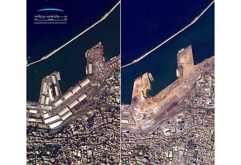

The Union of Arab Emirates' KhalifaSat electro-optical satellite has captured a bird's eye view of the great devastation caused by the giant explosion that on the afternoon of August 4th devastated the port of Beirut and a large part of the city.
Orbiting at an altitude of 613 kilometres, the images captured by the Emirates observation platform and disseminated by the Mohammed bin Rashid Space Centre in Dubai are already helping the Lebanese authorities, the United Nations and international emergency agencies to determine the extent of the damage and to plan the priority actions to be taken to restore basic water, electricity and gas services and to provide assistance to the victims.
In a first approach, the Lebanese President, Michel Aoun, and the Government of the Prime Minister of Lebanon, Hassan Diab, estimate that the accident has left around 150 dead and missing, some 5,000 injured and between 250,000 and 300,000 homeless, who must be fed and treated for their injuries and in the face of the COVID-19 pandemic that also affects the city's population.

Thanks to the images captured by KhalifaSat and other observation satellites before and after the explosion, remote-sensing analysts can assess the severity of the damage and establish the urgency of interventions and priority tasks. By passing KhalifaSat about 14 times every 24 hours over the affected area, the authorities involved in emergency operations can assess the progress of the actions of the relief teams on the ground.
Engineers and architects can plan the reconstruction of devastated areas, of destroyed or damaged buildings within a radius of several kilometres, organise the cleaning of streets full of debris, act on roads with the pavement raised and remove the thousands of overturned vehicles and fallen trees due to the direct effects of the explosion and its shockwave.

It weighs 330 kilos, is 2 metres long and less than 1.5 metres in diameter. It has four solar panels that power the equipment on board, especially the operation of its 40-centimetre digital camera and the high-resolution sensors on board, which weigh a total of around 70 kilos.
The small KhalifaSat provides high-resolution images of 30 square kilometres of land in the visible and infrared spectra with a resolution of 75 centimetres per panchromatic pixel - in black and white - and 2.98 metres per multispectral or colour pixel. This makes it possible to know the extent of visible and not-so-visible damage from the ground.

The 2014 project of the Dubai Institute of Science and Advanced Technology, which from April 2015 will be called the Mohammed bin Rashid Space Centre, has the merit of being the first satellite built in the Emirates by a team of the country's engineers led by engineer Amer al-Ghafri.
Based on the SI-300 platform of the Korean company Satrec - like its predecessors DubaiSat-1 and 2 - the first tasks were carried out in Korea. But starting in February 2015, the Korean and Emirati engineers moved to the new facilities of the Mohammed bin Rashid Space Center in Dubai to continue their work until the completion of the satellite in early 2018.

Initially known as DubaiSat-3 but later officially named KhalifaSat, it has on board a high speed system for data download and communications, GPS positioning, as well as automatic control and advanced target location equipment on which to focus your attention and take pictures.
With an estimated lifetime of five years in space, it was launched on October 29, 2018, from the Tanegashima Space Center in Japan, aboard the Mitsubishi Heavy Industries (MHI) H-IIA rocket, along with the 1.8-tonne Japanese GOSAT-2 and half a dozen other small satellites from various countries.

The correct launching and good management of KhalifaSat's take-off operations demonstrated by the technicians of MHI and the Japanese Space Exploration Agency (JAXA) were to the full satisfaction of the Emirates authorities. So much so that the Martian probe Al-Amal also repeated a flight from Tanegashima on board an H-IIA on 19 July.
The big brothers of the KhalifaSat are the DubaiSat-1 (190 kg) and the DubaiSat-2 (300 kg), which were built in Korea. Both were launched in July 2009 and November 2013, respectively, from the Russian Baikonur Cosmodrome on board the also Russian Dnepr rockets. In both cases they were placed at an altitude of about 680 kilometres, but their performance is lower than that of the one that remains in service and feeds images of the disaster to the authorities of the United Arab Emirates and Lebanon.


